 Vegetation Resource Monitoring
 |
Vegetation Resource Monitoring |
|
|
• Modified Robel PoleA modified Robel pole is a tool and associated technique that can accurately measure in ½ inch increments the available residual vegetation in any grassland or mountain meadow community. The technique is simple to learn, reliable, easily repeated, cost effective when used for monitoring, and can be used to cover large areas of rangelands or meadows. In addition, the modified Robel pole technique is more precise and less time consuming compared to estimating utilization by ocular methods or compared to clipping, drying, and weighing vegetation methods. Best of all, management decisions can be made immediately after summarizing measurement results for any pasture. Results can be compared to pre-determined management objectives stated in the Forest Plan or Allotment Management Plan for residual vegetation criteria. A Robel pole is a 4-foot tall pole with alternating gray and white bands that start with zero at the pole bottom
(first band) and increase in ½ inch increments (bands) up the pole. This pole is attached to a second pole at least one
meter in height by a 4-meter long string. A reading of the highest visible band that is not blocked by residual
vegetation is recorded by an observer sighting to the banded pole from the height of the second pole with the string pulled
tight between. The Robel pole technique of measuring residual vegetation is the same regardless of where data is to be collected
and the method is easily learned. To achieve sample adequacy criteria, data is generally collected from four two-hundred meter
transects for areas equal to a section of land (640 acres). Each transect requires 4 individual readings at 90° from the
previous reading around the banded pole at 20 stations spaced 10 meters apart along each two-hundred meter transect. Thus, the
result of each transect is based on the band average of 80 separate measurements of the residual vegetation. Then the band
average of the four transects are averaged for a pasture average of residual vegetation. A Robel pole measures the vegetation
currently remaining in a pasture instead of estimating what is gone--
|
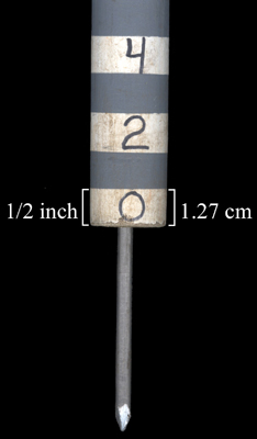
modified Robel pole 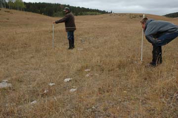
measuring residual vegetation with a modified Robel pole | ||
• Contiguous Daubenmire FrameA contiguous Daubenmire frame is a tool and technique that uses a series of five adjacent 0.1 m2 plots (50cm x 20cm) marked the same way as the Daubenmire method intended (Daubenmire 1959) to include the boundary definition for each of the 5 contiguous smaller plots. Each 0.1 m2 plots originally marked by Daubenmire is reduced by a factor of 5, thus represents 20% of the extended frame (0.5m2). This creates the situation where the area that originally represented 5% of the 0.1 m2 plot now represents 1% of the 0.5 m2 plot. Measurements are more precisely made by 1% increments of an individual species or other category (litter, rock, total cover etc.). The method can be used to monitor vegetation change on mine lands for pre- and post-disturbance, reclamation success, and be used to establish long-term monitoring plots to monitor vegetation trend in different plant communities (Bonham et al. 2004). The contiguous Daubenmire frame method can also be incorporated into rare plant monitoring protocols because the 0.5 m2 plot size is ideal for annual photographic documentation which can provide individual plant location information that can be linked to life history data collected for individual plants. Life history data is often neglected in many rare plant monitoring protocols and is greatly needed to provide land managers with necessary information for population trends, viability analyses, and conservation measures. |
| ||
|
Photography shows how monitoring of individual Botrychium hesperium plants and associated vegetation can be collected prior to any planned habitat disturbance. Life history characteristics of individual plants and pre-disturbance condition of vegetation can be easily recorded and documented using photos. After the disturbance, repeat monitoring procedures can be completed to assess impact to habitat and individual plants. The photograph below was taken in the Colorado Mountains. 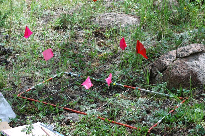
monitoring Botrychium hesperium using a contiguous Daubenmire frame Below is a Daubenmire frame study of post-mine land disturbance in Colorado. Graphs illustrate long-term mine land reclamation results of plant cover monitoring. The same sample plot locations were monitored each year. 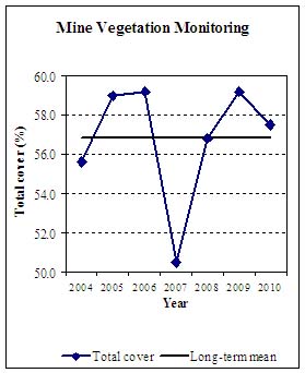
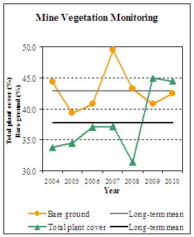
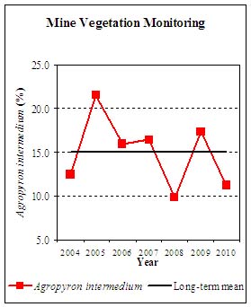
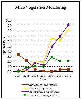
Annual photographic comparisons can also be made with the technique since each plot can be permanently established and sampled in following years. Results of baseline and trend monitoring of vegetation in sub-alpine plant communities in the Greenhorn Mountains, Colorado, are illustrated below. 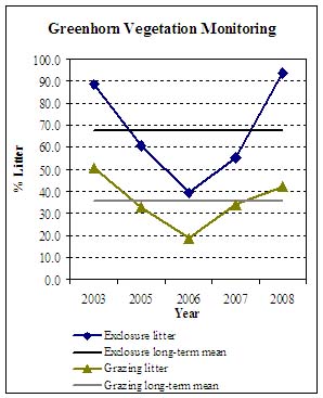
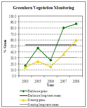
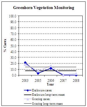
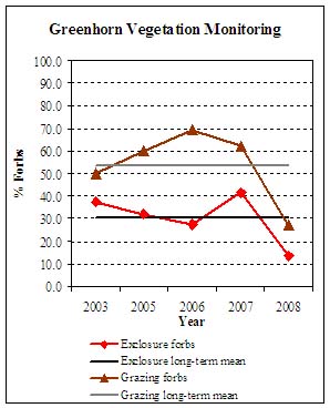
Long-term trend and average for litter, grass, Carex and forb canopy cover inside and outside of an exclosure. |
|
|